An Integrated System for Road Condition Diagnosis and Management

 Introduction
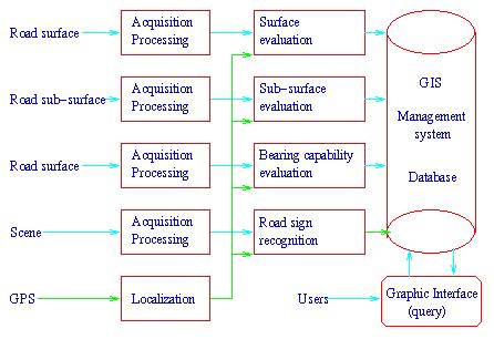
The GRPR, Ecole Polytechnique, is developing an integrated system for road
diagnosis and management in collaboration with the National
Research Council of Canada and GIE
Technologies Inc., a Montreal consulting company. The integrated system
involves road data acquisition, modules( surface and sub-surface condition,
bearing capability, traffic sign position and condition) and a road data
management system using GIS (Geographic Information
System), GPS(Global Position System and relational database
technologies.
Project Facets:
System Architecture
Members involved
Ecole Polytechnique: Prof.
Paul Cohen, Prof. Jean-Yves
Herve, Dr. WeiBing
Tong,Valerie
Gouailler, Denis
Fourt, Arnaud
Lina.
GIE: Dr. L. Bursanescu.
NRC: Dr. F. Blais.

 Some Related Info on Road Diagnosis and Management
Companies
-
Roadware Inc. -Home Page
-
Lambda Tech International Inc.- Home
Page
-
GIE Inc.-Home Page
Geographical Information System
-
Fugawi Moving Map Navigation Software
for GPS Receivers
-
EMap GIS OCX Control by EMap Technologies
-
Facet Decision Systems, Inc.
-
MRC - Measurement Research Corporation
-
ADC Home page
-
Etak Incorporated (Digital Maps & Geocoding)
-
Geographic Data Technology, Inc.
-
Genasys Main Browse
Area
-
NIS Home Page
-
Caliper. Corporation Home Page
-
MAPCOM Home Page
-
GIS Transportation
Links
-
About Bentley
-
Intergraph Online
-
Welcome to ESRI!
-
Spatial Knowledge Systems bv
-
Hipparchus Geographic Software Tools
from Geodyssey
-
Edinburgh Geographical
Information Systems(GIS)
-
MapInfo Map Data Database
-
Cartegraph Inc.
GIS free software
-
Introducing GRASS-XMI
-
WWW Database Query and
Map Generation via the WWW - Online Resources
-
GRASSLAND's
FAQ
-
Fre GIS
- Free Geoinformation-systems
-
GRASS info
Pavement Deflection Measurement
-
Deflection
Calculations and Measurements
-
WA-RD
3.3 PAVEMENT DEFLECTION MEASUREMENT
-
QUEST Integrated, Inc. - Home Page
-
International
Roughness Index (IRI)
-
Nondestructive
Evaluation Techniques
-
Dynatest Inc. -Home Page
Stereo Vision System for Map Making
-
Welcome to Mandli Communications, Inc.
-
The University of Calgary
Geomatics Engineering Home Page
-
Lambda Tech International - Home Page
-
Center For
Mapping GPS Van Project
Pavement Management System
-
MRC - Measurement Research Corporation
-
Welcome
to EG&G
-
PETIA'S HP: PMS and
GIS
-
MTO Integrated
Highway Information Systems
-
PaveNET-A World-Wide-Web
site for Pavement Engineering
-
Complete Street... Innovative
Software for Public Works
-
KIVA
Pavement Management System [KIVA]
-
Special topic:
Pavement Management
-
Cartegraph Inc.
GPS (Geographic information system)
-
3S Navigation TrueGNSS Home Page
-
SOKKIA CORPORATION - Home Page
-
Trimble Navigation Limited:
The GPS Solution
-
GPS Manufacturers
-
Welcome To GEOWAREHOUSE!!!
-
GPS World Home Page
-
OMNISTAR TM - The National DGPS System
-
About NovAtel
-
Navsys
-
Welcome To IZEE Labs And Communications
-
Northstar Home Page
-
CSE Computronics Ltd. -
Home Page
-
CMT - GPS TECHNOLOGY
-
Welcome to Ashtech
-
Ag Com AB - site
-
GPS Home Page
-
GPS Web BBS
-
The
Global Positioning System (GPS)
-
Land Surveying and
Geomatics: On-Line Resources
-
Global Positioning System
-
Land Surveyor
Reference Page
-
Map Maker - Free GIS for
Windows
-
Australia's First GPS Home Page
-
GPS World Home Page
-
MIT/LL GLONASS & GPS Home Page
-
Global Positioning System
(GPS) Resources
-
Leick GPS GLONASS
GEODESY Home Page
-
Navtech GPS Store
-
Global Positioning System
(GPS) Resources
-
Global Positioning Systems for Land
Surveyors
-
The Starlink DGPS Pages:
Home Page
-
NGS - National Geographic
Online
TONG WEIBING
Last
modified: Mon Nov 9 08:17:25 PST 1998